Hoosier Hill, Indiana Highpoint

Hoosier Hill: The highpoint of Indiana
June 2012 rolled around and I knew it was time: It was time to seek that highpoint that had been eluding me for all of those years – Hoosier Hill.
Yes, it was time to stand atop the highpoint of the state of Indiana. Oh, and I happened to be driving really close to it as I drove across the country to the east coast, so that helped, too.
Highpointing – the act of attempting to stand atop the highest point in each of the 50 U.S. states (or lower 48, depending on your exact definition) – was the brainchild of Arthur H. Marshall, who was the first known person to complete the 48 highpoints back in 1936. What was his last and final highpoint to complete the quest? The one and only Hoosier Hill.
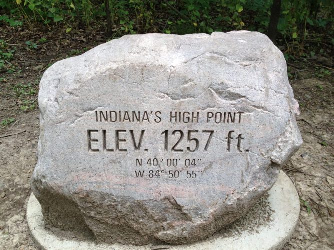
The highest natural point in IN
Date of hike: June 2012
The most harrowing part of the Indiana highpointing experience may be driving the rolling hills leading up to the hill. Route 227 runs parallel to the Indiana-Ohio border (it’s about 1 mile to the west) and leads you on a northbound roller coaster journey to an intersection near the hill. If you don’t obey the speed limit, your car may soon be attempting jumps and stunts that you didn’t exactly plan.
The area has an old feel to it and the roller-coaster-like ups and downs are surrounded by golden farmland swaying in the breeze. After driving across the entire state of Indiana, it’s easy to notice that terrain seems so much different than the rest of the state. Survive the rolling hills and a couple of twists and turns and you’ll soon stand atop the highest point in Indiana.
Up about a mile north from the Bethel Road and Elliot Road intersection, a small gravel parking lot is marked by a small sign on the road on the left. It’s easy to miss. It helped that there was another car parked there when we arrived otherwise we may have missed it.
After a 50-foot walk from the makeshift parking lot, head into a thicket of trees on your right to find a well-maintained patch of land complete with a picnic table and an old mailbox that holds a register and information cards.
The highpoint itself gets an ‘A’ for presentation, thanks mostly to a local Eagle Scout who revitalized the area in 2005.
Indiana is a pretty flat state, but even flat states have highpoints, and now you’ve been there – and probably learned a little something about Indiana in the process, too.
Getting to Hoosier Hill
Head north on Route 227 to Franklin Township. After about 10 miles (from I-70), turn left on Bethel Road. Follow Bethel Rd for about a mile, then take a right on Elliot Road. Head north on Elliot Rd. for about a mile – the small parking area is on the left and is marked by a sign at the road.
Hoosier Hill quick facts
Hoosier Hill
Elevation: 1257 ft.
Nearest town: Richmond, IN
Trail distance (estimate): 1/10 mile
Elevation change (estimate): n/a